
Try the
on familysearch.
They are hidden under the title England Jurisdictions 1851 and provide a google-based map of the country showing the parish and county boundaries. In addition you can click on a parish and get useful information. For instance for Hatfield it tells you:
Other places in the parish include: Woodside, Newgate Street and Roe Green
Parish records begin 1653, Bishop's transcripts 1603
Non-Church of England denominations identified in Bishop's Hatfield include Baptist, Independent / Congregational, Primitive Methodist and Wesleyan Methodist
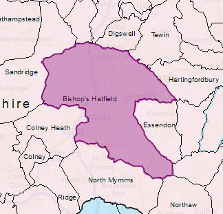
| Parish | Bishop's Hatfield |
For each of the jurisictions it is possible to get an appropriate map
| ||
| County | Hertfordshire | |||
| Civil Registration District | Hatfield | |||
| Probate Court | Court of the Archdeaconry of Huntingdon (Hitchin Division) | |||
| Diocese | Post 1844 - Rochester, Pre 1845 -Lincoln | |||
| Rural Deanery | Hertford | |||
| Poor Law Union | Hatfield | |||
| :Hundred | Broadwater | |||
| Province | Canterbury |
No comments:
Post a Comment
This is the newsletter for the Genealogy in Hertfordshire Web site. Comments on this blog are moderated and may be transferred to the web site where appropriate. If you have a local or family history query you want answered you must use "Ask Chris" - See box in right hand column. Anonymous comments cannot be answered.